Be a Mississippi-River "Model Citizen" – How to Walk from Baton Rouge to St. Louis in About An Hour
"You want to do what?"
--said my travel partner in response to my offer. (I was momentarily back in my childhood talking to a parent.) I had asked if we might briefly exit our three-day journey on the Natchez Trace to do a short hike, "say Baton Rouge to St. Louis." The Trace has a lovely way of lowering one's blood pressure so we in fact were ripe for exercise. As her interest peaked ever so slightly I started reading from an old Popular Science article (1) that I had on hand: "Commonplace at Clinton, Miss., in the 1950s: Men will speak of minutes as though they were days, of feet as though they were miles, and ripples in a test tube as though they were floods [with] North America's greatest river system in a concrete test tube...a working model of the Mississippi and all its important tributaries." I "read on" a little bit more then paused in silence:

"Let's see if am understanding this side trip," she finally said. "It involves walking a half mile along a model of the Mississippi aside an old German prisoner-of-war camp in the middle of the South, correct?"
Then (said she) "Let's do it!" Well, not quite. First we had to find it. Mobile phones offer pretty much "zero G" reception on too much of the Trace. But, very happily, a fully-stocked visitor center was right in Clinton. We exited near there, dropped by, and inquired of the meet-and-greeter at the front desk; his response: "You want to go where?"
Where
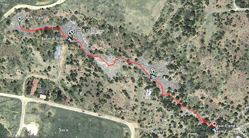
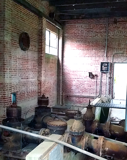
The "where" is a scale model of the entire Mississippi River drainage basin squeezed into 200+ acres. The cover term used by the U.S. Army was the Mississippi River Basin Model (its longstanding acronym is MBM). It is sited just off the Trace where Clinton and Jackson (MS) abut each other (appropriately inside a park named "Billy Butts"). Built by the Army Corps of Engineers (technically titled "Waterways Experiment Station") starting in the 1940s, it was intended to physically and hydraulically "simulate" the flow and floods of the entire Mississippi River basin, both the river proper and its tributaries; it is now over four decades abandoned. The visitor-center greeter knew of it (yay). Had I time to chit-chat I would have told him I expected it might be a little adventurous, "almost archaeology" (2), but the day was getting late. He promptly fished out a good map of the region as a giveaway, opened it, and then put an X on the location of the MBM. He looked for an additional handout/factsheet in his file cabinet but couldn't find it ("not that common of a request" said he). I did find it later online here (on pp. 4-5 of this Acrobat pdf).
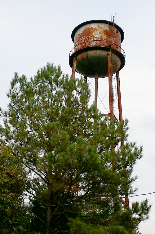
With such a map (or, if one is lucky, using Google Maps with GPS turned on one's phone and 4G available) it's tolerably findable. One might have to watch for errant golf balls as one make one's way in (the "Tee Time" driving range now borders the entry road on the west side of Butts Park). The water tower was a good target-marker for MBM visitors like us:
There's 60+ years of printed matter about the site and plenty of web hyperlinks that I'm sharing herewith.
Well before our roadtrip I had found the Popular Science piece (quoted above), initially having printed it for several reasons: written a couple years beyond postwar America, it was now history, hopefully factual and thus of practical use. And it oozed journalistic charm that one does not see much these days. But now, reading it in the car, whoah: the tone sure is parental, perhaps patriarchal, and there's even a little feel of persuasive "MadMan copywriting" that had yet to arrive back when it was penned. The piece was well supported with figures and photographs, though at the time some images were "artist's conceptions:"

A postwar "think big" slogan is hinted at in its tone (big is good, but biggest is best). "Control" is good, too, as our great Mississippi (folks then must have thought) would surely benefit from more of that. The arrival of America's "Eisenhower Era" -- it "was it was."
On site
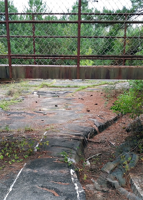
We parked near a point that we first could view the MBM, though it is all pretty overgrown and initially seemed to have a uniform look and feel, i.e., alternately concrete and jungle. "Don't wear sandals," I cautioned my traveler (all that overgrowth includes poison ivy). We dodged a dilapidated fence and hopped over a steel and concrete bunker onto the largest uninterrupted plain we could find:
I turned on my smartphone GPS and started a recording a track. In hindsight we had found the equivalent of the Mississippi Delta, circa "Baton Rouge:"

The only direction to take was, well, "upstream." A bit oddly, true compass direction (towards St. Louis) was not north, rather southeast.
"The model will cost ... $6,000,000 (3) [and] will settle arguments that have raged since the French started building levees at New Orleans in 1717 about where more levees, dams. reservoirs, etc. are most needed and the types of structure that will be most useful." My traveler and I live and work near St. Paul, Minnesota, so we thought we might respect the writer's lead and retrieve some "Old-Man Working-River vocabulary" as we started talking/walking around; but my glossary (in hindsight) would have to include terms such as bed, berm, bridge, channel, divot, levee, spillway, weir, etc. I decided to take photographs and add GPS waypoints at interesting-looking spots for possible future reference.
"The model will cover 220 acres. It will depict 41 percent of the United States ... including 17,500 [actual] miles of rivers. The brooks that babble across the model's surface will be eight miles long." We only had an hour, not exactly suitable for "miles of babbling." The scale of the model was (and is) 1:2,000 horizontal (but -- interestingly -- 1:100 vertical.) My walking gate is about 18 inches, so each of my steps might represent a little over half of "a real mile." We could walk the MBM to where -- about St. Louis? -- in our allocated time, with stops for photography, checking my geotracking, personal reflection, and shared conversation.
We could discern a main channel of the Mississippi right away without a lot of trouble, so off we went:

There was immediately a smallish side-channel to the left, in hindsight I determined it was a likely path to the Red River Valley (a tributary to the Mississippi perhaps to be "discovered" by us another time).
Yikes, is there a "code book"?
"The river beds and valleys will be long, zigzagging strips of concrete varying in width from a few feet to several yards," continued Popular Science. Yes, that was exactly what was there -- and is now -- to be seen.
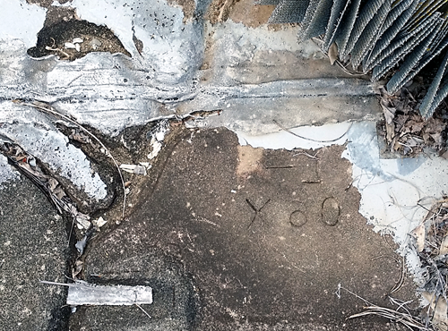
"The rolling land between these winding waterways will be sodded. Signs will mark the sites of cities..." Sod and signs were very long gone. Labels with letters and numbers of some sort were painted or debossed into concrete:
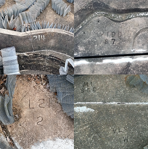
But who has the builder's "code book"? (We didn't.) One couldn't really get very lost, but then again one couldn't easily discern exactly where a city -- be it large or small -- might be, that is, unless one was a retired airplane pilot from (say) 1966 (when the MBM was completed) who might have committed the entire mid-American ground appearance to longterm memory.
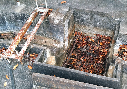
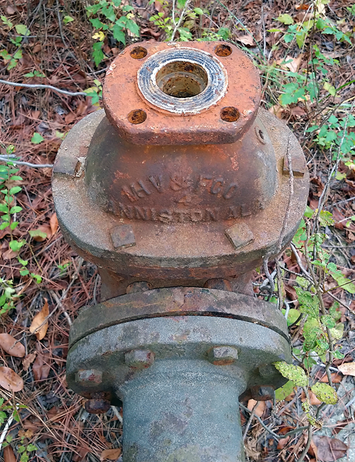
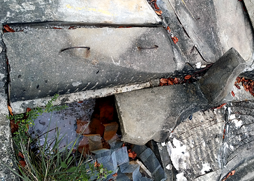
"There will be 15 miles of storm sewers, big water mains, and a maze of wire from electrical instruments below the surface." Remnants of rusted water mains or couplings appeared here and there, but only an engineer might be able to guess at anything below ground:
Storm sewers were planned and required during construction in order to permit accurate hydraulic modeling; stated another way, actual rainwater would spoil its intended function so MBM needed serious (and I imagine costly) diversion of all localized rain. Over the hour's walk we encountered several viewing areas, for example ducking under one low (but still stout) observation bridge both going and returning:
Vicksburg is here (maybe)
After walking 400 feet I saved my first track and unceremoniously labeled it "basin track A." Without that code book I knew not where I was. In hindsight I think was near Vicksburg, MS (perhaps) having traversed about 160 fake miles.
We were wholly witness to -- decay. As I pondered all the materials of basin construction in front of me, some exposed, other hidden, I asked myself: How was the MBM built, and of what? I figured with lots of its historical "makings" still lying around, then perhaps I should gather samples as an "almost-archaeological-audit" (though I wouldn't grid a couple-hundred acres with wire or twine first and mark everything like an archaeology pro does).
Popular Science, 1948, continued:
"Model builders [used hundreds of] metal patterns to make small-scale replicas of main river beds, levees, and spillways ... Concrete [was] poured and molded to conform to top edges of suspended templates ... Minor details [were] molded in the surface by hand:"
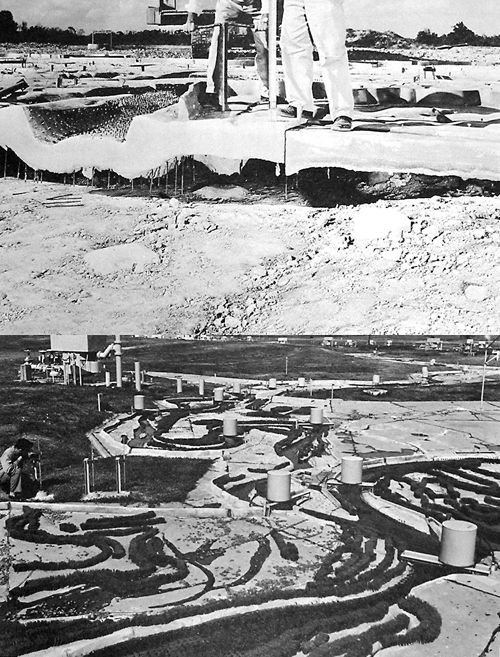
Images courtesy U.S. Army Engineer Waterways Experiment Station, 1971.
The excerpt above seemed utterly plausible, but as I mentioned most everything seen is transforming itself into something else -- though a fair number of my snaps that I shot orthogonally "downward" (as if aerial photos) felt more like abstract art compositions: me (to my fellow traveler), "I have what looks like a lovely Cubist Feininger from 1920 here:"
...Traveler: "Yay, and there's a nice deKooning circa 1948 over here:"
As we departed Vicksburg I started new GPS track and continued "up north" at my half-a-mile per-step.
Osceola?
We dallied briefly for conversation and photos at what probably was Memphis then paused at -- Osceola, Arkansas. I judged it as such in hindsight because I had saved another track (B) at the spot, noticing that about 700 feet of walking had accrued, or about 280 more miles upriver. Several years back the History Channel offered viewers a broadcast titled "Life After People," you may have seen it or perhaps read an article or book with a similar theme. In a similar way we were watching nature "take the model back." We were there on the week just past Labor Day and colors were "turning" slightly; one such red-orange-tinged tree was growing out of a channel:
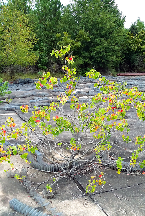
Sight lines -- which 40 years back would have been completely uninterrupted -- were now beautifully "cluttered" by nature and newish micro-forests. I wondered: were things growing a little faster now due to climate chaos?
Popular Science, continued, pertaining to MBM's "core function":
"The great floods of 1912, 1927, 1937, 1945, and 1947 ... can be re-enacted. Conditions that may arise in the future can also be simulated." I later checked historical records for Osceola during those years and, sure enough, it was reported as wholly inundated in April 1927 and then again a decade later, in January (1937). 1927 was the worst flood in Arkansas' history.
Interestingly, "Popular Science 1948" offered a hypothetical scenario to describe "how to mitigate a potential Memphis-area flooding" within its narrative: "Suppose ... that men in charge [of huge reservoirs each in Kentucky and Montana] were to release water independently. The result would be a catastrophic flood in Memphis. Suppose, however, that scientists ... [Army Corps folks] in Mississippi [were told] 'Reproduce present conditions on the river ... then add water at rates a times corresponding to those at which these reservoir operators say they'll discharge it.' -- 'Gosh boss this looks bad.' [Boss:] 'I'll phone Hank Johnson at Fort Peck [to] change ... schedules...so that nobody will get wet at Memphis, or anywhere.'"
"That can save Uncle Sam billions" continued Popular Science. This struck me as a pretty strident argument for government funding, as much a civil-engineering sales-pitch as journalism.
St. Louis (but no arch)
The last leg was another 600 feet or 240 scaled miles. That would've put us near St. Louis, but of course that remained hard to judge exactly; in 1948 it was missing its Gateway Arch, though the arch would have opened in St. Louis a year before the model was fully completed (1966). Later I found no statements evident about whether or not any such architectural landmarks (at scale) had ever been worked into parts of the model as guideposts for tourist visitors.
We liked our walk so far but it would end soon. I wondered, what kind of attraction was MBM in its heyday? Once back home I investigated that question and found tidbits pertaining to its popularity:
"During its period of basin-wide testing the MBM gained international renown as a tourist attraction. Beginning in 1964 visitor facilities provided self-guided tours on a seven-day-a-week basis. Facilities included a visitor assembly center, a 40-foot-high observation tower, an operation observation room near the center of the model, and elevated platforms, walks, and sidewalks at selected locations throughout the area ... Through the remainder of the decade the model drew about 5,000 visitors a year." Not Disneyland I thought, but still impressive.
I logged a final waypoint and labeled that leg track C; back home I later opened the whole walk, part by part, into Google Earth:
By that time my pockets were full of artifacts that I would later photograph for assembly into an archaeologist's "finds collection:"
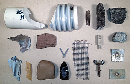
Being an almost archaeologist I may never know what all these materials were. At that time I wondered who now owned these two-hundred-plus acres. Turns out that the model was put "on standby" for possible future use in 1971; eventually, MBM was to utterly give way to computer modeling. Army folks awarded "custody" of the property itself to the City of Jackson in 1973.
With a thought bubble marked "ethics" above me I decided that technically my final finds collection was "checked out" from the Army (or that would actually now be Jackson), like library books, to be returned later. Geocaching is an activity becoming more and more popular, perhaps I can get a hold of locals who are good at that, wherein savvy geeks leave little artifacts to be "found" by other equally-savvy geocache fans.
Conspectus: mixed notes on the past, present, and future of MBM
I called out to my fellow traveler, "meet me in St. Louie"! Together we drew our nearly 700 mile walk to a close as dusk arrived. We then drove to inspect the water tower and a couple of derelict structures nearby:
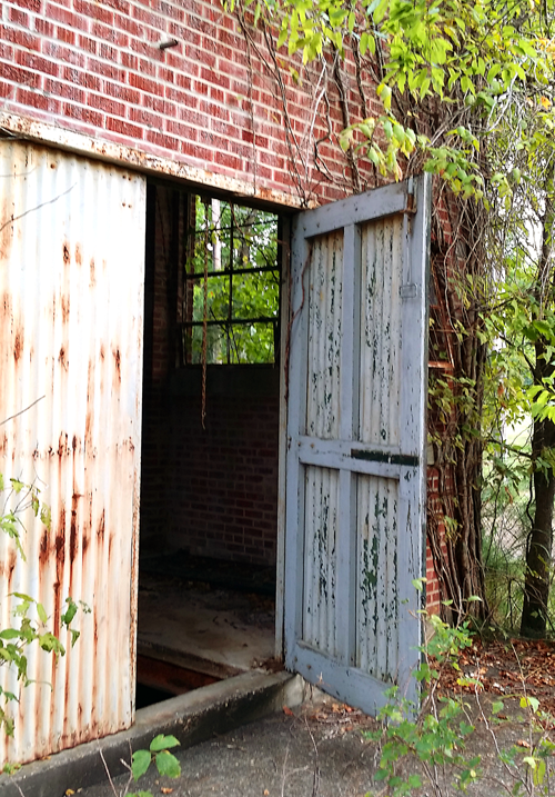
I opened squeaky doors to decayed interiors, something like you might see in a set for "Terminator" or "Halloween" flicks:
As part of some prefatory research I had encountered some fascinating backmatter pertaining to World World-II: the basin had been excavated by German POWs during the latter war period who were living in barracks on site; a snapshot of barracks here:

...and of workers here:
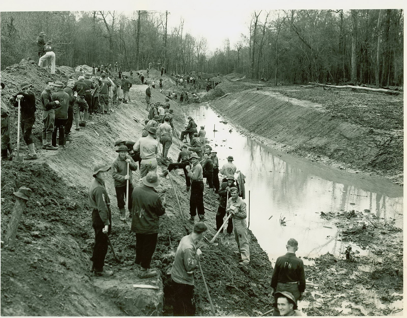
Before we arrived on the MBM site I had seen a public-facing sign featured in a website photograph that marked the original barrack location; once on site, try as we may, we could not locate that sign, it must be gone. The prisoners in the mid-1940s were of Rommel's "Afrika Korps," i.e., his desert soldiers who were captured overseas then relocated to Clinton in order to toil at earthmoving "1,000,000 cubic yards," the latter a figure reported by Popular Science (but that's a whole 'nother story).
As far as I could tell what happens today at the modestly-tended Butts Park is golfball-driving, cross-country tournaments, soccer practice, ATVing, disc events, geocaching, and maybe radio-controlled (RC) artifact racing. I had seen an informative and clever movie clip documenting the current state of the basin model, at its end featuring a few seconds of RC auto contests on the basin model; it's worth a look. I contacted the local RC-vehicle indoor-facility in the nearby town of Flowood (MS) to inquire if the basin was in fact seriously accommodating such RC events. "Not to my knowledge," said my respondent. I'm probably missing other civic "creative-hobbyist" activities that happen in or around the basin (or otherwise, e.g., Walmart's HQ is only one state away, might it want to test its future corporate "heli-drone delivery-plans" around here?).
Speaking of heli-drones, in the months and years ahead both "helicopter parents" and Butts Park rangers may cast slightly suspicious eyes on this aging MBM. (We were utter loners there that afternoon.) The site was designated a "state of Mississippi landmark" as of 1993 when the Army washed its hands of the matter. I doubt if checkbooks will open much to fund any significant reversal to its decay -- right now there is no worry about regaining those 5,000 visitors a year I quoted earlier. We noticed the model has embedded within it thousands of square feet of small "mesh-screen" accordions whose function back then was to dampen the water flow so it performed more like a real river when hydraulics were being tested at its model scale. At this point in time it seemed clutter that one needed to take care not to trip over; I felt like shoveling it all out of the way, sort of "tidy up" the place nicely for future visitors:
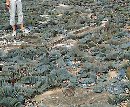
Instead I merely picked up one of the many small accordion-steel pieces and pocketed it for use later.
It is decaying, indeed physically and, in a way, "culturally." Five years back one online source posted a full report of the MBM with "decay" as a word-stub within its URL here.
For at least a few folks it indeed may be becoming something of a pop culture icon, not only almost archaeology but perhaps "almost art" as well. Witness intentional decay as an art form with Adrián Villar Rojas and colleagues' "The Evolution of God" site-specific sculpture in New York City's west side last year: "[Our] sculptures will ... turn into living organisms, revealing the passage of time through vegetal sprouts and tectonic cracks, which will slowly return the sculptures to the surrounding landscape."
Avid industrial archaeologists might like to capture MBM "as it is" now. If donation checks somehow started to fly then folks could "LiDAR-scan" MBM into a digital model (something museums do these days -- working with technical vendors to scan their collections, be they architectural miniatures, priceless sculptures, or whatever). At that point it would become "a model of a model," that is, a digital model of the basin model itself. As the Discovery Channel (and Hollywood) has demonstrated with special effects these days anything can be done with digital models (e.g., age the model's decay much more rapidly, or, the opposite, slowly, perhaps as intended by the work of artist Rojas previously mentioned). Maybe all this would give folks an "attack of historical regret" such that a campaign to "save the model" might arise, i.e., to transform it into what, perhaps the South's biggest outdoor museum?
Could it ever offer us "equal-parts" culture, learning, and entertainment? I was thinking MBM has joined its many compatriots under the cover phrase of "civil miniaturization," now part of my list which would include a personal favorite -- the 1:400 scale model (in plaster) of ancient Rome:

...and one still on my bucket list -- a famous model railroad that I have yet to see.
One thing that a group of entrepreneurs is doing today is making concrete puzzles out of landscapes that one can purchase by way of the group's Indiegogo venture. So, "MBM, the puzzle" -- to be sold at the Clinton Visitor Center?"
Such "civic creativity" that could be part of MBM's distant future seems endless.
Homework (me) and fieldwork (you)
If Army Corps "code books" exist I'll try to find one, or at least there must be a decently-printed geo-referenced base-map of MBM. (If you don't hear from me it may be because, like the MBM itself, I may have ended up being put "in custody" by the Feds!) I could scan such a map and then "digitally rubbersheet" it atop my final Google Earth track. I would then really know if we ended our nearly 700 fake miles at St. Louis (or not; disclaimer: we might well have taken a wrong turn and ended up in -- Louisville!).
Some readers may want to put a visit to -- and audit of -- MBM on a list of their own "future fieldwork." If so, one might also "pair" that model-citizen-sojourn with a side trip to "the real" nearby Vicksburg, MS, whose Mud Island River Park holds yet another walkable model of the Mississippi; titled RiverWalk; it is much newer, more compact, and seemingly more kid-friendly than MBM ("barefoot" is do-able).
Notes
1. Specifically, it's Volta Torrey's "The World' Biggest Working Model," 1948 (April), POPULAR SCIENCE, 115-120. Some good news: Popular Science has a generous copyright and asset-sharing policy that I wish to acknowledge and credit text and image excerpts herewith. Bad news: the hyperlink to the target 1948 issue that I extensively quoted requires lots of scrolling upon your arrival at the URL. And depending upon your age and intrinsic attraction to old issues of Popular Science you'll experience anew -- or "relive" -- a lot of ads.
2. AlmostArchaeology.com is an engaging digital online journal whose slogan is "see Archaeology in Everything!" and its mission is "to find meaning in pop culture archaeology and explore the ways in which archaeology enters the public imagination." This illustrated essay in a shorter version was first posted at Almost Archaeology's website here.
3. Six million dollars may not be the total and true cost; one research source (Mississippi Department of Archives and History) indicates that that figure was merely the estimated value of the POW's three years of labor. I couldn't help but wonder: might there be master's theses or Ph.D. dissertations awaiting studious folks in order to address the full complexity of MBM in whole or in part?
Credit: copyediting help courtesy Brendan Byrne.