Cape Town Without The Freeways

Cape Town's Foreshore freeway strangles the city and cuts it (and its people) off from the Port and water's edge. With a comparison to San Francisco's Embarcadero, Gareth Pearson questions what would happen if we did away with the Foreshore section of Nelson Mandela Boulevard altogether.
When Capetonians talk about the freeway along the Foreshore, there's a good chance it involves a joke about the mysterious unfinished sections. It's not the unfinished sections that I care about, it's the entire thing.
The footprint of the freeway as well as the land in between each section is wasted, restricting the development of this lifeless area of the city. There have been a number of interventions proposed, as mentioned some time back in a post by Andrew Boraine. More recently, the City of Cape Town, is proposing a 3 storey parking building to sit between the freeways, to support a new tower, as part of the Convention Centre expansion.
There is often talk of sinking the freeway below ground, a monstrous project not disimilar to Boston's Big Dig. Sure, this is an option, as with any project it has its advantages and disadvantages. But what if the freeway was removed entirely? What if it was replaced with a tree-lined boulevard that accommodates public transport, bicycling, and walking?
It's very easy to quickly shut this idea down as one visualizes the hoards of single-occupant vehicles trying to enter the city. How will motorists effortlessly get to the bottom of Buitengracht Street and on to other parts of the city? The big question here is whether the city would cope with a lower-capacity roadway in place of the freeway.
Enter The Embarcadero, San Francisco's boulevard that runs along the water's edge. The roadway is lined with trees, and is shared by trolley cars, bicyclers, pedestrians, and motorists. This was once the route of a double-decker freeway, that like Cape Town's Nelson Mandela Boulevard, cut off the city from the water's edge.
The earthquake that shook the city in 1989 forced the closure of this vital artery into San Francisco. One would think that the sudden closure would have caused havoc, and that it would have needed to be repaired and reopened. The city soon realised that it was coping just fine as citizens adapted to the situation. The damaged freeway was removed to create the inviting boulevard that is there today.

San Francisco's Ferry Building strangled by the Embarcadero freeway before the 1989 earthquake that led to its closure.
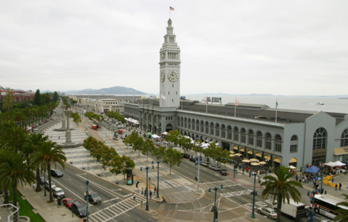
The Embarcadero today - a tree-lined boulevard that invites citizens to the restored Ferry Building and the water's edge.
The Embarcadero is now a space that invites optional and social activities like leisurely walking and cycling. The Ferry Building, a vibrant transport hub and now also a sustainable food dining destination, is easily accessible from the city center. Where the view down Market Street would have once led the eye to a double-decker monstrosity of a freeway, one now sees the clock tower of the Ferry Building reaching for the sky, marking a destination in the city.
So perhaps Capetonians too would adapt, and moving the points at which citizens enter the city out would do more good than harm for city life. Could we one day look down a bustling Heerengracht Street in Cape Town towards our own Ferry Building on the water's edge? I certainly hope so. If the proactive political will is not there, I'm crossing fingers for an earthquake.